

Topographic map 1:100,000 - map 29 - Hulst
Topographic map 1:100,000 - map 29 - Hulst
Low stock: 1 left
Ordered before 3pm on weekdays, shipped on the same day
Couldn't load pickup availability
Your purchase is subject to our terms and conditions. Please double-check your order and completed details before completing the order.
Description
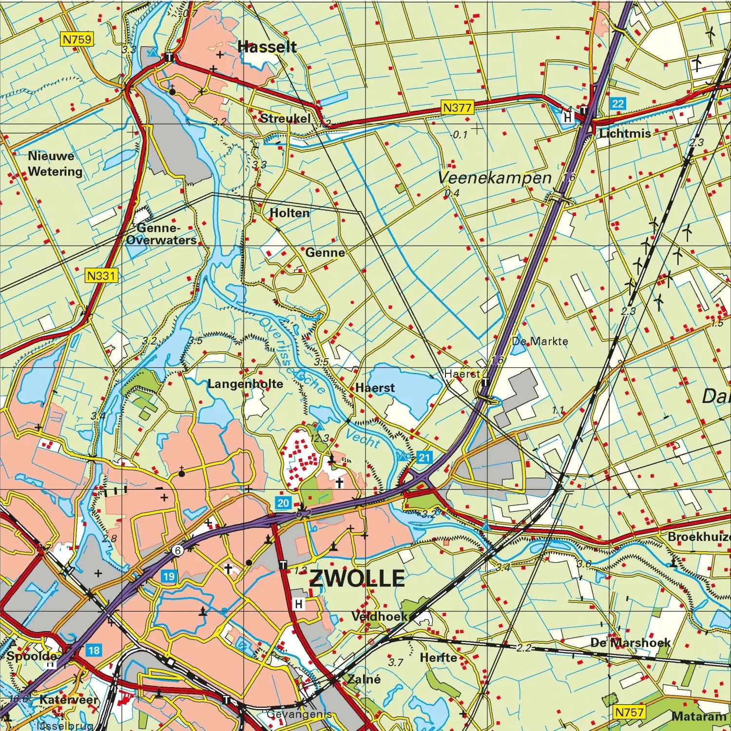
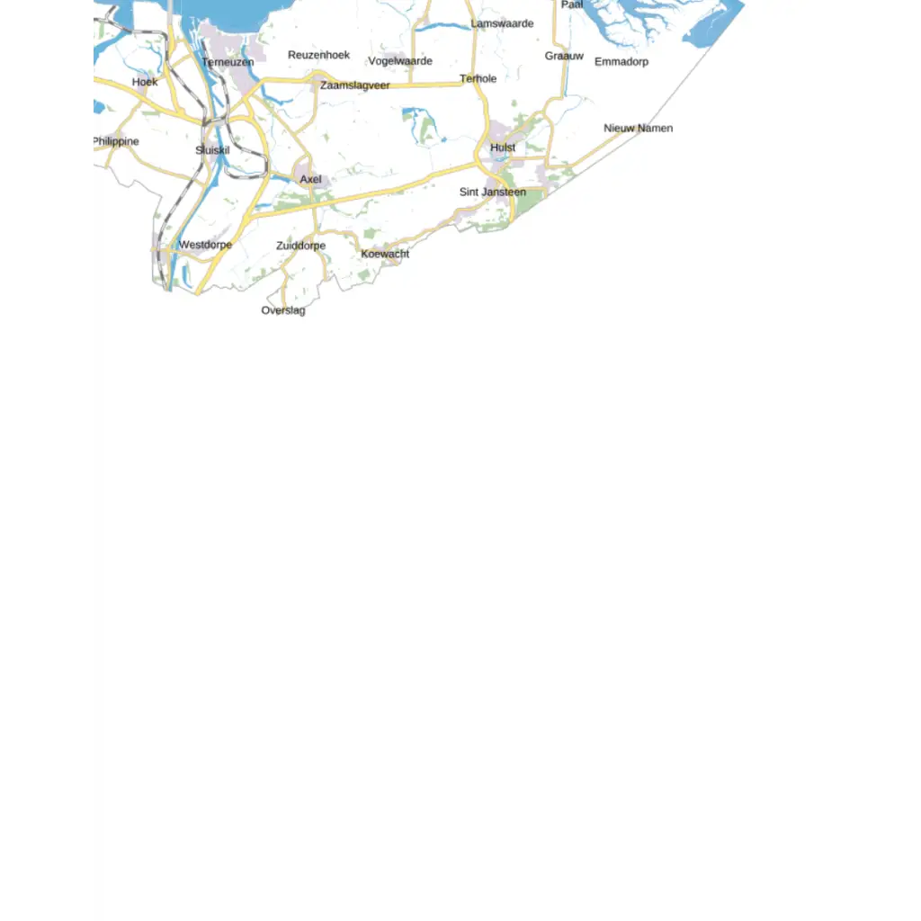
One of the most detailed topographic maps available through sales channels. Created by the Dutch Topographic Service, this map contains a large part of the topographic elements of the landscape and thus gives a fairly accurate picture of the terrain.
The map is printed in multi-colour and is delivered folded. The map has a map image of 40 x 50 cm, which corresponds to 40 x 50 km in the terrain. The size of the map sheets (map image plus legend and edge information) is 59 x 84 cm.
In addition to use in professional circles, the topographic map is often used for GPS use (coordinates are neatly displayed in a km grid), scouting and survival training, but also by an ever-growing group of hikers. Now that the tourist hiking maps are strangely becoming of increasingly poor quality, the topographic map remains the only alternative.
Terneuzen, Philippine, Axel, Vogelwaarde, Hulst, Clingen, New-Namen, Koewacht, Westdorpe, Paal.
See an example of a map below to see the level of detail:
-
1-person Blackout Pack for 3 days
Regular price €155,00 EURRegular priceUnit price per -
1-person Blackout Pack for 7 days
Regular price €275,00 EURRegular priceUnit price per -
2-person Blackout Pack for 3 days (incl. walkie talkies)
Regular price €249,00 EURRegular priceUnit price per -
4-person Flood Survival Pack for 3 days (incl. walkie talkies)
Regular price €995,00 EURRegular priceUnit price per -
3-person Flood Survival Pack for 3 days (incl. walkie talkies)
Regular price €899,00 EURRegular priceUnit price per -
2-person Defense Pack for 3 days
Regular price €695,00 EURRegular priceUnit price per -
2-person Blackout Pack for 7 days (incl. walkie talkies)
Regular price €395,00 EURRegular priceUnit price per -
4-person Blackout Pack for 3 days (incl. walkie talkies)
Regular price €314,00 EURRegular priceUnit price per -
1-person Flood Survival Pack for 3 days
Regular price €475,00 EURRegular priceUnit price per -
6-person Blackout Pack for 3 days (incl. walkie talkies)
Regular price €539,00 EURRegular priceUnit price per -
2-person Cyber Attack Pack for 30 days
Regular price €1.295,00 EURRegular priceUnit price per -
1-person Senior Survival Trolley for 3 days
Regular price €529,00 EURRegular priceUnit price per -
3-person Defense Pack for 7 days
Regular price €935,00 EURRegular priceUnit price per -
2-person Defense Pack for 7 days
Regular price €810,00 EURRegular priceUnit price per -
1-person Defense Pack for 7 days
Regular price €515,00 EURRegular priceUnit price per -
5-person Flood Survival Pack for 7 days (incl. walkie talkies)
Regular price €1.599,00 EURRegular priceUnit price per -
5-person Flood Survival Pack for 3 days (incl. walkie talkies)
Regular price €1.399,00 EURRegular priceUnit price per -
5-person Cyber Attack Pack for 7 days
Regular price €1.295,00 EURRegular priceUnit price per -
5-person Cyber Attack Pack for 3 days
Regular price €680,00 EURRegular priceUnit price per -
4-person Cyber Attack Pack for 7 days
Regular price €1.050,00 EURRegular priceUnit price per -
4-person Cyber Attack Pack for 3 days
Regular price €595,00 EURRegular priceUnit price per -
3-person Cyber Attack Pack for 7 days
Regular price €895,00 EURRegular priceUnit price per -
3-person Cyber Attack Pack for 3 days
Regular price €520,00 EURRegular priceUnit price per -
2-person Cyber Attack Pack for 7 days
Regular price €659,00 EURRegular priceUnit price per -
2-person Cyber Attack Pack for 3 days
Regular price €395,00 EURRegular priceUnit price per


